

Seeing through the haze
You can’t have a good sunset at the beach without clouds. Fortunately for sunset lovers, coasts are among the world’s most prolific cloud generators. Any SoCal locals who are familiar with our “June Gloom” know this. While clouds make great sunsets, they are also problematic for ocean measurements. Electro-optical (EO) and infrared (IR) wavelengths can’t penetrate clouds. That means clouds block remote measurements for a number of high value parameters including sea surface temperature, as well as optical data used to map algal blooms and track the movements of life over vast areas.
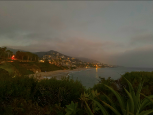
A view of coastal clouds forming over Laguna Beach, a short drive from HyperKelp’s main office.
Why do so many clouds form over our coasts? The answer lies in the phenomenon of frictional coastal convergence. Over land, air tends to move more slowly. This is because the surfaces of continents are a lot rougher than the ocean’s surface. As air moves inland, fast moving air from the relatively slick ocean meets air that is moving more slowly over land. Moisture collects at the coasts and some of the air is forced to rise. The rising, moist air produces clouds. This is why coasts – more than most places on Earth – are blanketed by frequent cloud cover.
Because EO/IR wavelengths can’t penetrate clouds, it means that clouds block remote measurements for a number of high value parameters including sea surface temperature, and optical data used to map algal blooms and track the movements of life over vast areas. Supporting these remote datasets when the weather blocks conventional measurements is why we’re building persistent sensor platforms. It’s also why we’re starting our first deployments near the coasts. By deploying Kelp Smart Buoys (KSB’s) along the coast, we ensure that accurate measurements are delivered regardless of cloud cover, or proximity to shore.
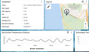
An ODaaS Dashboard streaming data from a Kelp Smart Buoy deployed in Torrey Pines, CA. Though it’s a challenging marine environment to measure remotely, KSB’s excel here. HyperKelp has been streaming data from the lagoon more or less continuously since early 2021.
For an example of this, check out the KSB dashboard (above) with a real time SST feed. This KSB unit is moored in a coastal lagoon in Carlsbad. Coastal lagoons are among the most challenging environments to measure remotely, because they’re frequently cloaked in cloud cover. What’s more is that they’re too close to shore for many satellite-based sensors to resolve the difference between water and land. As a result, even in ideal, cloudless conditions, measurements like SST can appear “smudged” without any ground truth.
If you need to collect or ground truth measurements that are limited by cloud cover – like sea surface temperature, or chlorophyll concentrations – let us help you! We have the gear and infrastructure to generate real time data feeds from any point on the Earth’s surface, regardless of the weather above.
Contact us at: founders@hyperkelp.com OR (949) 273 9723